Soils of the UW
Rogers Research Site
By Larry C. Munn, Stephen E. Williams, Michael A. Urynowicz, and Robert W. Waggener
Rogers Research Site Bulletin 6
June 2018

north Laramie Mountains, Wyoming
Rogers RESEARCH SITE BULLETIN 6: Soils of the University of Wyoming’s Rogers Research Site, north Laramie Mountains, Wyoming
By Larry C. Munn, Stephen E. Williams, Michael A. Urynowicz, and Robert W. Waggener
Layout and design by Tanya Engel
University of Wyoming College of Agriculture and Natural Resources
Wyoming Agricultural Experiment Station
This is Bulletin 6 in an ongoing series focusing on research, teaching, extension, and other activities at the University of Wyoming’s Rogers Research Site (RRS) in the Laramie Mountains, north Albany County, Wyoming. The approximate 320-acre site was bequeathed to UW in 2002 by Colonel William Catesby Rogers.
Colonel Rogers spent much of his retirement time at the mountainous, remote property, which he called the Triple R Ranch. UW renamed the property “Rogers Research Site” in memory of Colonel Rogers, who passed away in 2003 at age 96.
The February 16, 2002, amended living trust of Colonel Rogers states that:
said ranch be used for the public benefit as a center for studies, a retreat for conducting meetings, conducting conferences, or conducting research in connection with the improvement of wildlife and forestry, or to hold as a natural wooded area in its original state with specific instructions that no part of it be subdivided or sold for residential or private business purposes but held as an entire tract. Said restriction is to continue in perpetuity. If violated, said property shall revert to the ownership of the U.S. Forest Service.
Overseeing management of RRS is the Wyoming Agricultural Experiment Station (WAES), UW College of Agriculture and Natural Resources. RRS is placed administratively under one of the WAES research and extension centers, the James C. Hageman Sustainable Agriculture Research and Extension Center (SAREC) near Lingle, Wyoming.
ii
Copyright © by the University of Wyoming. All rights reserved. Readers may make verbatim copies of this document for non-commercial purposes by any means, provided that this copyright appears on all such copies. For other uses, please contact the Wyoming Agricultural Experiment Station at aes@uwyo.edu, or University of Wyoming, WAES, Dept. 3354, 1000 E. University Ave., Laramie, WY 82071-2000.
SUGGESTED REFERENCE
Munn, L. C., Williams, S. E., Urynowicz, M. A., and Waggener, R. W., 2018, Soils of the University of Wyoming’s Rogers Research Site, north Laramie Mountains, Wyoming: University of Wyoming, Wyoming Agricultural Experiment Station, Rogers Research Site Bulletin 6, iv + 38 p.
ON THE COVER
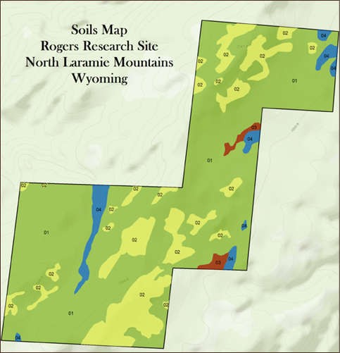
General soils map of the Rogers Research Site, showing the boundaries of the Alderon (01), Cathedral (02), Dalecreek (03), and Kovich (04) series. (Soils mapping by lead author Larry Munn; digital GIS and cartography work by Shawn Lanning, Wyoming Geographic Information Science Center [WyGISC]; base map from Esri World Topographic Map).
WYOMING AGRICULTURAL EXPERIMENT STATION
Bret Hess, associate dean and director
John Tanaka, associate director
University of Wyoming, Dept. 3354
1000 E. University Ave.
Laramie, WY 82071-2000
email: aes@uwyo.edu
phone: (307) 766-3667
RESEARCH & EXTENSION CENTERS
Laramie R&E Center (LREC)
Scott Lake, interim director
University of Wyoming
1174 Snowy Range Road
Laramie, WY 82070
email: lrec@uwyo.edu
phone: (307) 766-3665
www.uwyo.edu/uwexpstn/centers/laramie
Powell R&E Center (PREC)
Bret Hess, interim director
747 Road 9
Powell, WY 82435-9135
email: uwprec@uwyo.edu
phone: (307) 754-2223
www.uwyo.edu/uwexpstn/centers/powell
Seed Certification: (307) 754-9815 or (800) 923-0080; mdmoore@uwyo.edu
Seed Lab: (307) 754-4750; seed-lab@uwyo.edu
James C. Hageman Sustainable Agriculture R&E Center (SAREC)
John Tanaka, director
2753 State Highway 157
Lingle, WY 82223-8543
email: sarec@uwyo.edu
phone: (307) 837-2000
www.uwyo.edu/uwexpstn/centers/sarec
Sheridan R&E Center (ShREC)
Brian Mealor, director
3401 Coffeen Ave.
Sheridan, WY 82801-9619
email: shrec@uwyo.edu
phone: (307) 673-2856
iii
DISCLAIMER
Mention of a proprietary product does not constitute a guarantee or warranty of the product by the Wyoming Agricultural Experiment Station (WAES) or the authors and does not imply its approval to the exclusion of other products that may also be suitable.
Persons seeking admission, employment, or access to programs of the University of Wyoming shall be considered without regard to race, color, religion, sex, national origin, disability, age, political belief, veteran status, sexual orientation, and marital or familial status.
Persons with disabilities who require alternative means for communication or program information (Braille, large print, audiotape, etc.) should contact the state WAES office on the University of Wyoming campus in Laramie, Wyoming, or a local WAES Research and Extension Center in Laramie, Lingle, Powell, or Sheridan, Wyoming. To file a complaint, write to the UW Employment Practices/Affirmative Action Office, University of Wyoming, Department 3434, 1000 E. University Ave., Laramie, WY 82071-2000.
Be aware that due to the dynamic nature of the World Wide Web, internet sources may be difficult to find—addresses change, and pages can disappear over time. If you find problems with any of the listed websites in this publication, please contact WAES at (307) 766-3667
or aes@uwyo.edu.
Issued in furtherance of State Agricultural Experiment Station work of the 1887 Hatch Act, as amended through public law 107–293, November 13, 2002, in cooperation with the U.S. Department of Agriculture. Bret Hess, director, Wyoming Agricultural Experiment Station, University of Wyoming, Laramie, Wyoming 82071.
iv
About the authors
LARRY C. MUNN
Lead author Larry Munn is a professor emeritus of soil science in the University of Wyoming’s Department of Ecosystem Science and Management. He started as an assistant professor at UW in 1981, and was promoted to associate professor in 1986 and professor in 1992. Munn conducted his soils studies at the Rogers Research Site (RRS) from 2009 through 2014, both before and after the high-intensity Arapaho Fire. Since retiring in 2014, he completed his writing and mapping work for this bulletin. He is among the more than 40 UW faculty members and students who have been directly or indirectly involved in a variety of soils- and forestry-related studies at RRS. He says the site has good potential for additional research, and encourages both graduate and undergraduate students to develop and carry out studies with their faculty mentors. “I believe there are many opportunities up there, for example a soil genesis project and the post-fire restoration of organic matter in the forest soils over time,” Munn says.
While at UW, Munn focused his research across Wyoming on soil genesis, morphology, and classification; soil–native plant community relationships; mine land reclamation; and the effects of coal-bed methane development on soils and landscapes. Munn also taught a number of undergraduate and graduate classes at UW, including “Introduction to Soil Science” and “Genesis, Morphology, and Classification of Soils.” Additionally, he led a number of special-topic courses focused on the research of soil–geology–plant relationships in native, agricultural, and drastically disturbed ecosystems. He received the John P. Ellbogen Meritorious Classroom Teaching Award in 1993 and was named the UW College of Agriculture’s1 “Outstanding Teacher” in 1999.
Munn earned a B.S. in agronomy (emphasis on soils) in 1972 from The Ohio State University, an M.S. in natural resources (forest soils) from OSU in 1974, and a Ph.D. in crop and soil science (range soils) from Montana State University in 1977. After joining the faculty at UW, Munn served on the western regional coordinating committee of the National Cooperative Soil Survey (NCSS), including two years as committee chair; the soil taxonomy and soil interpretations committees of the NCSS; and the soils and geomorphology committee of the American Society of Agronomy.
Munn is a member of the Board of Supervisors of the Laramie Rivers Conservation District, one of 34 conservation districts across Wyoming. In his volunteer work with LRCD, Munn believes that the district plays an important education role in Albany County when it comes to helping landowners conserve natural resources. Additionally, he says, “It is vital to assist youths and young adults with agriculture production and living on small-acreage plots within the county.”
STEPHEN E. WILLIAMS
Professor Emeritus Steve Williams oriented his teaching and research career at the University of Wyoming toward soil microbiology, forest and range soils, and soil chemistry/biochemistry so he felt right at home when digging his first soil pit at the mountainous Rogers Research Site.
“Late in my career at UW, I started work at the RRS, a new site slated for forestry- and wildlife-related research in the Laramie Peak area of southeast Wyoming. The ecosystems at RRS have taught me much, but I am cowed in the face of what we do not know.”
Williams has been intimately involved with the early research at RRS, including the post-
1

1In 2009, the UW Board of Trustees approved renaming the college the College of Agriculture and Natural Resources.
fire ponderosa pine restoration project that was detailed in Bulletin 5, as well as soils-related studies contained in this bulletin and two upcoming bulletins that are nearing completion.
Williams earned a B.S. in biology at New Mexico State University (1970), an M.S. in agronomy from NMSU (1972), and a Ph.D. in soil science from North Carolina State University (1977).
His career at UW spanned from 1976 through 2013, and since retiring he and his wife, UW Professor Emeritus Karen Cachevki Williams, have operated an environmental and educational consulting business.
MICHAEL A. URYNOWICZ
Michael Urynowicz is a professor of environmental engineering in the University of Wyoming’s Department of Civil and Architectural Engineering. He joined the faculty at UW in 2002 as an assistant professor, and was promoted to associate professor in 2008 and full professor in 2014. He has authored or co-authored more than 35 journal articles, books, and book chapters, and he holds three patents.
Urynowicz directs the Center for Biogenic Natural Gas Research within the UW School of Energy Resources. The center develops and commercializes technologies that enhance the production of renewable, clean burning natural gas in coal seams and other fossil fuel reservoirs using indigenous microorganisms.
He earned a B.S. in chemical engineering at Michigan State University in 1990, an M.S. in civil and environmental engineering at the University of Wisconsin in 1995, and master’s
2

Michael Urynowicz enjoys a trekking adventure to the Annapurna Himalayas of north-central Nepal in 2006. The prominent mountain in the background is Machhapuchhre, elevation 22,943 ft (6,993 m). Also spelled Machapuchare, the mountain is considered sacred and is closed to climbers.
and doctorate degrees in environmental science and engineering at the Colorado School of Mines in 1998 and 2000.
His principal areas of teaching and research are chemical oxidation processes for the degradation of chlorinated solvents; in situ remediation of contaminated soil and ground water systems; stabilization of metals through redox technologies; onsite and alternative wastewater treatment systems; carbon sequestration within coal formations; and mitigation of coal bed methane produced water; among others.
ROBERT W. WAGGENER
Wyoming native Robert Waggener has spent four-plus decades exploring Wyoming’s mountain ranges, from the Wind River, Wyoming and Absaroka ranges in western Wyoming, to the Bighorn Mountains in the north-central part of the state, to the Medicine Bow and Laramie mountains in southeast Wyoming. During trips to the Laramie Peak area of the north Laramie Mountains, he was awed by the rugged beauty—a mix of towering ponderosa pines and massive granite boulders. It was this same beauty, along with the isolation, that drew Colonel William C. Rogers to Wyoming, where he found that perfect place to retire just a short distance from that prominent peak that Waggener and his brother, John, would hike up years later.
When Waggener was hired by the Wyoming Agricultural Experiment Station to coordinate the Rogers Research Site bulletin series, it was a project that would blend his personal interests in the state’s great outdoors, wildlife, and plants along with his professional career as a writer, photographer, and editor, work that now focuses on agriculture and natural resources in Wyoming and the West. When Waggener began working with others on the RRS project, he faced one recurring question: “Who is Colonel William C. Rogers?” People knew that he donated his mountainous land near Laramie Peak to the University of Wyoming, but beyond that he was a mystery. Since these bulletins
are not only for a scientific community, but a general audience, too, Waggener felt compelled to answer the question he began facing at every turn in the project. “Who is Colonel Rogers?” Since this fell outside of the scope of his work directly tied to the Rogers Research Site bulletin series, he voluntarily spent many, many hours tracking down and then interviewing people who knew The Colonel. Their stories of this most fascinating, remarkable man have provided an introduction to each bulletin, and it’s Waggener’s hope that readers are not only finding these stories interesting and educational, but that they also bring a personal side to the land he donated to UW. “I have had the opportunity to read the will of Colonel Rogers, and it was obvious he believed in the education of young people,” Waggener notes. “The Colonel would be proud knowing that undergraduate and graduate students, working with their faculty mentors and others, are now hiking across that very land, conducting studies that are furthering their educations while bolstering our knowledge base about forest ecosystems and their importance to our state and beyond.”
3
Robert Waggener on top of Laramie Peak (10,272 ft [3,131 m]) in southeast Wyoming’s north Laramie Mountains. He and his brother, John, hiked up Laramie Peak in 2001, accessing the mountain from the west side at Friend Creek. Rogers Research Site is approximately 5 mi (8 km) southeast of the peak.
Standing on the Colonel’s Shoulders
Colonel Rogers turned cow patties into compost for his garden in the mountains
By Robert W. Waggener
“The fairest thing in nature, a flower, still has its roots in earth and manure.”
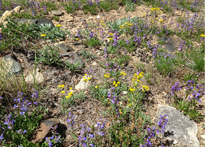
Decorated Army officer William Catesby Rogers loved reading plays, poetry, and prose by authors like D. H. Lawrence, who penned that famous quote. He relished walking through the ponderosa pine forests and meadows covered with wildflowers growing in the rocky soils (Fig. 1). And he enjoyed laboring on his retirement property in Wyoming’s rugged environment, where he worked on rustic cabins (Fig. 2), chopped firewood, and collected cow manure for his vegetable garden and strawberry patch. The north Laramie Mountains is a tough place to grow plants—high elevation, a fleeting growing season, and rocky soils lacking organic matter. And Rogers, like Lawrence, knew that the roots would require a little attention, that the hard soil would need softening so they could breathe.
“Even though the property is at 7,100 feet and the growing season is short, Bill and his hired hand, Jim O’Brien, had a very nice vegetable garden,” recalls Colleen Hogan, who spent many summer days on The Colonel’s hilly property with her mother, Levida Hileman. “They grew onions, garlic, green beans, sweet peas, tomatoes, kale, and lettuce. They also grew strawberries. For every strawberry we picked, Bill told us that we would have to pull two weeds. I remember pulling a lot of weeds,” adds Colleen, laughing. “The Colonel didn’t police us, but he made it known that pulling weeds was a requirement for eating strawberries and staying on his land.”
The Colonel scoured his land for cow patties, collected sawdust from the portable mill on his property, and drove up and down the alleys of nearby Wheatland, Wyoming, for bags of green grass and dried leaves, knowing that mixing these ingredients together with a little water would result in rich, dark compost—and bigger, better, more plentiful strawberries. This eccentric millionaire could have hired someone to haul dump truck loads of commercially made compost to his 320-acre Triple R Ranch, but instead he made it himself. And that started with understanding the principles behind compost, like getting the carbon-to-nitrogen ratio right, which meant mixing a certain amount of carbon-rich dried
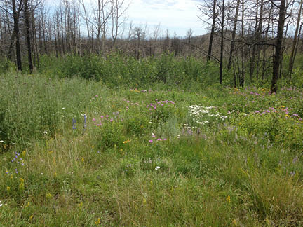
Figure 1. A variety of wildflowers and grasses grow in the rocky soils at Rogers Research Site, named in memory of Colonel William C. Rogers. This photo was taken in June 2015, approximately three years after the Arapaho Fire burned across nearly 100,000 acres of the north Laramie Mountains, including RRS. (Photo by Mollie Herget)
4
leaves and sawdust with a certain amount of nitrogen-rich cow manure and green grass. “The Colonel knew folks all over the world, and he wrote to monks in Tibet or somewhere to get their opinions on how to make good compost,” says Brock Hileman, who began visiting Colonel Rogers in the mid-1980s after meeting Levida and later marrying (Fig. 3). “He led a very simple life
while living on the land up there despite having lots of money. Someone would pay him a fee to let them graze cattle, and those cattle would leave their big messes around. Then The Colonel would go pick them up.”
Brock and Levida share a laugh as the compost story continues. “Oh, yes, he would push his wheelbarrow around the property, wearing old baggy boxer shorts but no shirt,” Levida recalls. “He would collect all the cow patties and put them in this old wheelbarrow (Fig. 4). You can imagine what he looked like. He was in his 70s, pretty skinny, walking around without a shirt. The Colonel could get away with it because he was so unique, so different.”
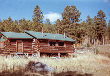
Figure 2. Colonel William C. Rogers, along with his hired hand, friends, and guests, stayed in rustic cabins, including ones that took a bit of labor to make them inhabitable, including this one, informally known as the ‘North House.’ (Photo by Colleen Hogan)
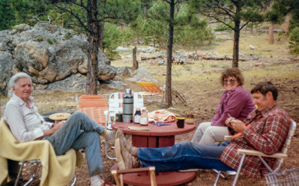
Figure 3. Colonel Rogers, left, enjoys a quiet afternoon visiting with friends Levida and Brock Hileman, along with Colleen Hogan (the picture taker), on his property in the north Laramie Mountains. This photo (from RRS Bulletin 1) was taken in the mid- to late-1980s. At the time, Colonel Rogers would have been about 80 years old. (Photo by C. Hogan)
5
Brock adds: “And eccentric, too. Maybe other people didn’t think so, but I sure thought he was eccentric.”
The folks down in Wheatland certainly saw the unconventional behavior of Colonel Rogers. After washing clothes at the local laundromat, he would spread them across the grass and on bushes at the Platte County Library, where he would spend time reading novels, poetry, plays, and how to make money investing in stocks. Or, if he needed materials for his compost pile, he would drive up and down the alleys picking up bags of yard waste and putting them in the back of his new Ford Bronco. “Yes, he was a very kind man, but he had a lot of eccentricities, including how he lived,” Colleen Hogan says. “He was a very proud man, a very intelligent man, but he was a hoot.”
“Memories and memories,” Levida quips. “Can I share one more story about this kind, generous, eccentric man?”
Her story starts not far from the compost heap, strawberry patch, and vegetable garden, where Colonel Rogers would entertain his friends and guests late each afternoon after a day spent reading, writing letters, and working the land. Sometimes they would sit around the campfire drinking Hamm’s beer and eating salted peanuts, or they would sip on mixed drinks in his meager, one-room cabin. “Yes, The Colonel liked bourbon. When I first took Brock up there to meet him, we went to his cabin and The Colonel offered him a drink,” Levida remembers. “Brock said, ‘Bourbon and water would be good.’ Now, The Colonel’s first home up there burned down, so when he moved into this cabin, he always kept a large open bucket of water by his stove. Of course this had ashes, flies, and wood chips floating in it. Well, Brock was stunned when The Colonel dipped an old glass into the bucket, filled it half full with water, and then topped it off with bourbon. Brock drank it, but when The Colonel offered him a second glass, he politely declined.”
Figure 4. The high-intensity 2012 Arapaho Fire burned the majority of ponderosa pine across nearly 100,000 acres in the north Laramie Mountains, including both young and mature trees at the Rogers Research Site. It also destroyed a number of homes and outbuildings in the mountains, including nearly all of the structures at RRS. Near the center of this photo, just to the left of the small storage shed, is the old wheelbarrow that Colonel Rogers used to collect cow patties for his compost pile. This photo was taken in March 2013, approximately nine months after the fire. (Photo by Jim Freeburn)
6
Soils of the University of Wyoming’s Rogers Research Site, north Laramie Mountains, Wyoming
By Larry C. Munn,1–2 Stephen E. Williams,3 Michael A. Urynowicz4, and Robert W. Waggener5
Introduction
When Colonel William C. Rogers bequeathed his “Triple R Ranch” to the University of Wyoming in 2002, he stated in his will that the 320-ac (129.5-ha) parcel of forested land in southeast Wyoming’s Laramie Mountains (Fig. 1) should be used, in part, for research relating to the improvement of forestry and wildlife resources (Rogers, 2002). One could argue that such research begins with the study of air, water, and soil—three natural resources that wildlife and forests depend upon. This bulletin focuses on soil as a natural resource, which includes the water that provides nutrients, the air that supplies oxygen, and heat through conduction. Understanding the ability and capacity of soil to support an ecosystem plays an important role in land-management decisions (U.S. Forest Service, 2017), including those involving both forestry and wildlife resources.
The Laramie Mountains are home to a rich array of resident and migratory wildlife species, which, in turn, depend on a great diversity of plants (more than 1,000 taxa have been identified) and habitats, including floodplains, grasslands, shrub lands, riparian areas, forests (Fig. 1), boulder outcrops, and rocky summits (Packer, 2000; Williams and Waggener, 2017a). The diversity of both animal and plant species across the range is largely due to wide ranging climatic variation associated with elevation and soils. Concerning the latter, five of the 12 orders of soil taxonomy are found in the Laramie Mountains: Alfisols, Aridisols, Entisols, Inceptisols, and Mollisols (Young and Singleton, 1977; Packer, 2000). Soils of the range are mostly moderately deep on hillslopes and generally low-nutrient status, shallow, and erodible. Along the water courses, soils are generally much deeper with higher organic matter, and they often have buried horizons. Erosion events can alter these soils periodically during periods of high rainfall, especially post-fire (Reckner, 1998). And soils can also be altered—in some cases quite dramatically—by fire itself.
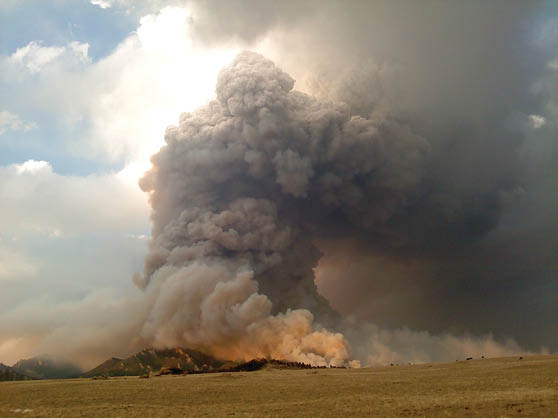
In 2012, the lightning-caused Arapaho Fire (Fig. 2) burned approximately
1For specific questions about this report (along with general questions about RRS research, information about access, driving directions to RRS, access to high-resolution digital copies of the bulletin, maps, etc.) please contact the James C. Hageman Sustainable Agriculture Research and Extension Center (SAREC) at sarec@uwyo.edu; 307-837-2000; or 2753 State Highway 157, Lingle, WY 82223-8543.
2Professor emeritus of soil science, University of Wyoming Department of Ecosystem Science and Management, Laramie, Wyoming.
3Professor emeritus of soil biology and biochemistry, UW Department of Ecosystem Science and Management, Laramie, Wyoming.
4Professor of environmental engineering, UW Department of Civil and Architectural Engineering, Laramie, Wyoming.
5Laramie, Wyoming-based freelance editor, writer, and photographer covering agriculture and natural resources in Wyoming and the West, and part-time editor for the Wyoming Agricultural Experiment Station.
7
KEY WORDS
Alfisols, Entisols, fire, Inceptisols, Laramie Mountains, Mollisols, ponderosa pine (Pinus ponderosa), Rogers Research Site, soils, soil mapping, taxajunct, University of Wyoming, vegetation, wildlife, Wyoming Agricultural Experiment Station
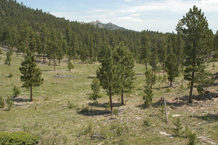
Figure 1. When Colonel William C. Rogers bequeathed his land in the north Laramie Mountains, southeast Wyoming, to the University of Wyoming in 2002, it was covered with dense and sparse stands of ponderosa pine (Pinus ponderosa) in various age classifications, along with grassy meadows and other habitat types. As discussed later in the paper, the Alderon soil has historically occurred on ponderosa pine-covered slopes like this, and it is by far the dominant soil at RRS. The photo (from Waggener, 2017) was taken in 2010, two years before the high-intensity Arapaho Fire burned across RRS and surrounding lands. (Photo by Steve Williams)
8
Figure 2. The 2012 lightning-caused Arapaho Fire burned about 98,000 ac (~39,700 ha) in the Laramie Mountains near Laramie Peak in southeast Wyoming. It consumed approximately 95% of the ponderosa pine forest at RRS. This photo was taken on June 29, two days after the fire started. (Photo by Josh McGee)
9
98,000 ac (~39,700 ha) in the Laramie Mountains (InciWeb, 2012), including the Triple R Ranch, which UW officially named the Rogers Research Site (RRS) in memory of Colonel Rogers. This high-intensity fire, which occurred during a severe drought, reached temperatures upwards of 900°F (500°C), killing the majority of ponderosa pine (Pinus ponderosa) and other vegetation throughout the area (Fig. 3; National Drought Mitigation Center et al., 2017; Williams and Waggener, 2017a). Fortuitously, researchers had already gathered a great deal of baseline data at RRS, including detailed mapping of vegetation (Seymour et al., 2017) and soils (Fig. 4; discussed below and in upcoming bulletins).
Study area
RRS is located on the eastern flank of the Laramie Mountains approximately 25 mi (40 km) northwest of Wheatland, Wyoming, and ~5 mi (8 km) southeast of the prominent Laramie Peak, the highest point in the range at 10,272 ft (3,131 m) (Fig. 5; Williams and Waggener, 2017a). The site is managed by the Wyoming Agricultural Experiment Station and one of its Research and Extension centers, the James C. Hageman Sustainable Agriculture R&E Center near Lingle, Wyoming.
Topography
RRS has an average elevation of ~7,000 ft (2,100 m), with elevations ranging from about 6,700 to 7,300 ft (~2,000–2,200 m). Habitats include (1) riparian areas (there are approximately five springs on the property) that support stands of quaking aspen (Populus tremuloides [Fig. 4]); (2) grassy and forb-covered meadows, with noxious weeds present in some areas; (3) gentle to steep slopes covered with ponderosa pine (P. ponderosa) of various age classes (Figs. 1, 6 [most of the pine would die during the 2012 Arapaho Fire]); and (4) rocky outcrops (Fig. 6).
Climate
The climate in the Laramie Mountains, including RRS, is semiarid with snowfall during at least half the year. Official National Weather Service data recorded at sites approximately 5 mi (8 km) southwest of RRS by rancher George Portwood indicate that the area received an average of 15.20 in (38.61 cm) of precipitation (rain and melted snow) per year from 1974 through 2015, while total snowfall averaged 83.23 in (211.40 cm) (Williams and Waggener, 2017b). These amounts are nearly double that of 2012, the year of the Arapaho Fire, when total precipitation measured 8.28 in (21.03 cm), and total snowfall was 47.50 in (120.65 cm) (G. Portwood, personal communication, 2017). The variations in temperature are also different (Table 1).
Table 1. Temperatures at Rogers Research Site, including the year of the Arapaho Fire (2012), and the average from 1974 through 2015.
|
Year 2012 |
42-Yr Avg. |
|
|
Average High (°F) |
67.71 |
73.81 |
|
Average Low (°F) |
34.63 |
10.72 |
|
Mean Temp (°F) |
51.17 |
42.27 |
Vegetation
Prior to the Arapaho Fire, RRS was predominately a ponderosa pine forest, with trees in various age classes covering approximately 80% of the land (Figs. 1, 6). The remainder of the site was mixed grass, forb, and shrub lands (10%), quaking aspen (4% [Fig. 4]), and other features, including rock outcrops, bare ground, and a reservoir fed by springs and natural precipitation (6%) (Seymour et al., 2017).
Wildlife
A variety of resident and migratory wildlife inhabit the area, including several economically important species: Rocky Mountain elk (Cervus canadensis nelsoni [syn. C. elaphus nelsoni]), mule deer (Odocoileus hemionus), bighorn sheep (Ovis canadensis), and wild turkey (Meleagris gallopavo). The area is also home to at least one species that is listed as “threatened” under the federal Endangered
10
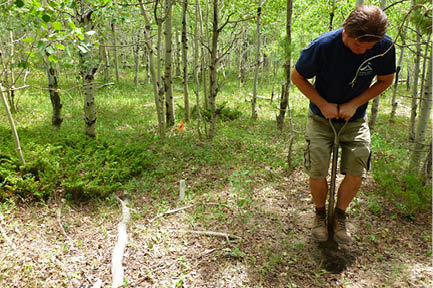
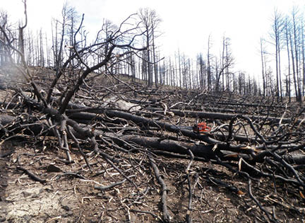
Figure 3. The high-intensity Arapaho Fire reached temperatures upwards of 900°F (500°C), killing the majority of ponderosa pine and other vegetation at RRS and surrounding lands. (Photo by Jim Freeburn)
Figure 4. University of Wyoming student Michael Curran excavates a soil pit in a quaking aspen stand at one of the research plots at RRS. This photo (from Williams and Waggener, 2017a) was taken June 22, 2012, during a project to map soils at various locations at RRS. Less than two weeks later, the Arapaho Fire swept across RRS property, burning the majority of the vegetation. This changed much of the research to post-fire, but some of the earlier studies involving vegetation and soil mapping are providing UW faculty, staff, students, and others with important baseline data. (Photo by Claire Wilkin)
11
Species Act, the Preble’s meadow jumping mouse (Zapus hudsonius preblei) (Williams and Waggener, 2017a).
Soils
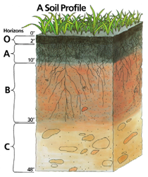
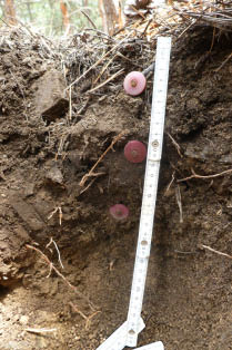
Research by authors L. C. Munn (Fig. 7) and S. E. Williams found that four of the 12 orders of soil are present at RRS: Alfisols, Entisols, Mollisols5, and Inceptisols, the latter of which were not mapped because of their small areal extent (see Appendix A for information about Inceptisols at RRS). Generally speaking (1) Alfisols result from weathering processes that leach clay minerals and other constituents out of the surface layer and into the subsoil, and form primarily under forest or mixed vegetative cover; (2) Entisols have little, if any, horizon development, and form in such locations as steep slopes; (3) Mollisols have a dark-colored surface horizon, are relatively high in organic matter, and characteristically form under grasslands; and (4) Inceptisols are the beginning of horizon development, and occur in a variety of climates, including semiarid (U.S. Department of Agriculture, Natural Resources Conservation Service, 2017). Figure 8 illustrates a ‘typical’ soil profile. The four major horizons include: a shallow organic horizon at the surface (O); topsoil (A); subsoil (B); and the parent material for the soil, or substratum (C). Figure 9 shows a fairly well developed soil profile at RRS (from Williams and Waggener, 2017b). The O horizon is constituted almost entirely of organic debris and partially decomposed organic materials. It extends from the surface to about 4 cm (~1.5 in). The second interval—from ~4 to ~11 cm (~1.5–4.5 in)—is the A horizon, which contains minerals, but also considerable organic C. The third interval from the surface is the B horizon (in this case, a horizon of accumulated clay), and it extends from about 11 to 17 cm (~4.5–7 in). From 17 cm (7 in) and deeper (out of the photograph) is the C horizon; here, the parent material is a sandy substrate (Williams and Waggener, 2017b).
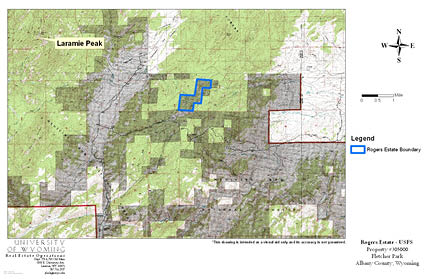
Figure 5. Location map (from Williams and Waggener, 2017a) showing the 320-ac (129-ha) Rogers Research Site (outlined in blue). The research site is approximately 5 mi (~8 km) southeast of Laramie Peak (10,272 ft [3,131 m]) in the northern reaches of the Laramie Mountains. Elevations at RRS range from about 6,700 to 7,300 ft (~2,042–2,225 m). The site is immediately surrounded by U.S. Forest Service (USFS) lands to the east, north, and west (light green) and state trust and private lands to the south (dark green). (Base map by USFS; RRS mapping by Josh Decker/UW Real Estate Operations)
5As discussed earlier in this bulletin, Aridisols, and perhaps others, are found elsewhere in the Laramie Mountains in addition to the four soil orders present at RRS.
12
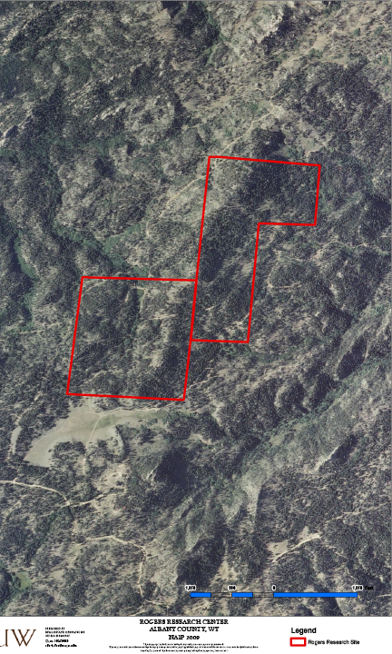
Figure 6. Aerial image of RRS and surrounding lands taken in 2009, three years before the Arapaho Fire. It shows a variety of habitats, including dense and sparse stands of ponderosa pine on gentle to steep slopes, riparian areas, meadows, and rocky outcrops. (Aerial image from National Agriculture Imagery Program; RRS mapping by Zarifa Dushdurova, courtesy J. Decker, UW Real Estate Operations)
Soils of the Rogers Research Site
At the Rogers Research Site (RRS), soils on forested slopes are moderately developed Alfisols and shallow Entisols with low inherent fertility and low water-holding capacity due to coarse texture. They are developed from granitic substrate. Mollisols are found under herbaceous vegetation cover along streams and in areas of springs and under dense aspen stands. These soils are deeper, finer textured, and contain more organic matter.
RRS has (1) thin to moderately deep and coarse-textured soils, which support coniferous forests on hillsides and ridge tops; and (2) thick, dark, fine-textured soils in areas where the water table is high, which support herbaceous vegetation in meadows and riparian zones. The soils change character consistently at the boundary between the forest and meadows or riparian zones. More subtle change occurs at the shoulder of ridges within the forest, where soils become thinner on the ridges. Rock outcrops are common in the RRS; in these areas, soils are very shallow and very low in organic matter. In the meadows, where the topography flattens along stream channels and the water table is closer to the surface, there are subtle changes in the soils, including textural (Fig. 10). Soils under the forest are light colored due to low organic matter contents and are acidic from the organic acids produced from the litter layer of conifer needles. The soils on the forest slopes are mostly “moderately deep” in soils terminology, 20 to 40 in (50 to 100 cm) thick. And, they have a layer of clay accumulation reflecting translocation from the surface mineral layer due to the acidity of the soil solution. Soils in the moist and wet meadows are dark colored because of below-ground organic matter accumulation and thick (50 in or more [100+ cm]) above the bedrock.
RRS Soils Described by Two SMUs
The soils of RRS are well described by two soil mapping units (SMUs) from the Soil survey of Albany County area, Wyoming (Reckner, 1998). The SMUs are 149, Dalecreek-Kovich
13
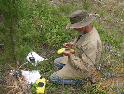
Figure 7. Lead author Larry Munn obtains Global Positioning System coordinates in 2012 at one of the sites in and adjacent to RRS where soils were sampled (the photo is from Waggener, 2017). This particular work was carried out shortly before the Arapaho Fire would burn across RRS and surrounding lands. (Photo by S. Williams)
14
complex, 0 to 9% slopes; and 213, Cathedral-Alderon complex, rock outcrops, 25 to 50% slopes. The representative soils for mapping units at RRS are classified as the following four series: Alderon (RRS-01), Cathedral (RRS-02), Dalecreek (RRS-03), and Kovich (RRS-04) (Fig. 11). Following are brief explanations (see Appendix A for detailed explanations; and please note that soil taxonomy has changed since publication of the Soil survey of Albany County area, Wyoming—the older classifications [from Reckner, 1998] are shown in parentheses before current terms [from Soil Survey Staff, 2014]):
In the Soil survey of Albany County area, Wyoming (Reckner, 1998), the U.S. Department of Agriculture’s Natural Resources Conservation Service (NRCS) mapped 38,914 ac (15,747 ha) of SMU 213 (Cathedral-Alderon), and 22,205 ac (8,986 ha) of SMU 149, Dalecreek-Kovich. We identified Entisols on the RRS as the Cathedral taxajunct. This is the shallow soil adjacent to rock outcrops under the conifers and is similar to the Cathedral Series mapped by NRCS during the Albany County soil survey except that it has lower organic matter content in the surface layer. Taxonomy for the Cathedral taxajunct is: loamy-skeletal, mixed, micaceous, frigid Lithic Ustorthents shallow (see Appendix A for detailed explanation).
Figure 8. A ‘typical’ soil profile showing the four major horizons: a shallow organic horizon at the surface (O); topsoil (A); subsoil (B); and the parent material for the soil, or substratum (C). (Illustration courtesy Natural Resources Conservation Service)
Figure 9. This photo shows a fairly well developed soil profile at RRS (from Williams and Waggener, 2017b). The O horizon is composed of organic debris and partially decomposed organic materials; it extends from the surface to about 4 cm (~1.5 in). The second interval, or A horizon, extends from 4 to 11 cm (~1.5–4.5 in); it contains minerals, but also considerable organic carbon. The third interval (B horizon) is a layer of accumulated clay extending from 11 to 17 cm (~4.5–7 in). From 17 cm (7 in) and deeper (out of the photograph) is the C horizon; here, the parent material is a sandy substrate. (Photo by S. Williams)
WHY THESE SOILS?
For soil scientists an important question is: Why are “these” soils on “this” landscape, now? The early Russian soil scientist Vasily Dokuchaev (1883) stated in the late 19th century that soils were the result of five soil-forming factors: parent material, climate, biota, topography, and time. Although this often-referenced model is useful in thinking about soils on a landscape, it’s not as simple as it might seem. The complexity of this model lies in the interactions between the factors that commonly occur. For example, climate exerts a large influence on the biota (vegetation), which influences soil development through the types and amount of organic carbon added to the system, as well as protection from erosion provided by the plant canopy and root system. Both climate and vegetation may affect soil-forming over time. For instance, drought may shift vegetation from forest to grassland, or, from grassland to desert shrub land. Glaciation may allow a landscape to be scraped clean of soil by direct ice action during a glacial period, resetting the time for soil formation back to zero. Segments not scoured by ice may be destabilized as a result of frequent freeze-thaw cycles and the action of frost. Or, if protected by forest and snow cover, they may retain pre-glacial soils throughout the glacial period. Even slopes that remain tree-covered with an insulating blanket of snow may undergo repeated mass wasting events. And, of course, forest fire also plays a critical role, offsetting the protection from erosion provided by living trees.
The soils of the RRS are also shaped by the interaction of the five soil forming factors. The geologic parent material at the site is primarily Precambrian granite, exposed by erosion after uplift of the region during the Laramide Orogeny (Snyder et al., 1995; Blackstone, 1996). The granite is very resistant to chemical weathering because of its chemical composition consisting of high silica content and, by default, lower concentrations of base cations calcium, magnesium, potassium, and sodium. It does, however, readily weather physically under the freeze-thaw cycles induced by the area’s climate, physically breaking up into particles of coarse sand and
15
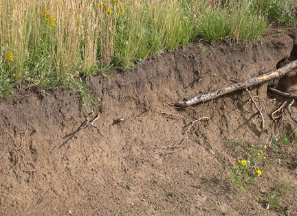
Figure 10. This photo shows a soil profile under grasslands at RRS. (Photo by S. Williams)
16
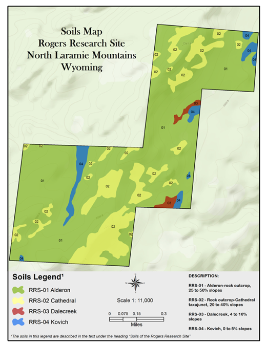
Figure 11. General soils map of the Rogers Research Site, showing the boundaries of the Alderon, Dalecreek, and Kovich soils, and the Cathedral taxajunct. (Soils mapping by lead author Larry Munn; digital GIS and cartography work by Shawn Lanning, Wyoming Geographic Information Science Center [WyGISC]; base map from Esri World Topographic Map)
small gravel. The low clay content and coarse, gravelly texture make the resulting soils drought sensitive and erosive. The vegetation at the site provided inputs of organic material into the soil and erosion protection. This type of landscape, however, is also subject to periodic fires that expose the bare surface to erosion. This is particularly true in coniferous forests on hillsides (Fig. 12), where the direct movement and re-deposition of fine particles to low landscape positions occurs, including foot-slopes (the lower slopes of hillsides) as well as banks along streams.
Because of the erosive nature of the landscape, soils on the upland hillsides are moderately deep despite the fact that the area was not directly glaciated during the Pleistocene. The combination of an ustic soil moisture regime in the uplands and a frigid soil temperature regime presents a relatively harsh environment for plant growth and limits soil chemical weathering. The overall result is shallow and moderately deep, coarse-textured soils containing limited organic matter on the steep slopes under coniferous forest and thicker, finer-textured soils with higher organic matter contents under herbaceous vegetation along the foot-slopes and stream channels. Aspen, a deciduous tree, occupies moist locations such as groundwater seeps and contributes significant leaf litter to the soil, which, in turn, further supports the growth of aspen (Fig. 4).
Soil Formation by Soil Series
Alderon Series (RRS-01)
The Alderon soil occurs at RRS where ponderosa pine forest has historically occupied the steep, convex upper side slopes, which typically range from 25 to 50% (Figs. 1, 12–17). The pine forest contributes acid-forming litter to the surface and, prior to the 2012 Arapaho Fire, provided stability to the surface through canopy coverage and root mass (Fig. 18). The forest litter layer adds organic acids to the soil at the surface, which facilitates clay leaching into the subsoil,
17
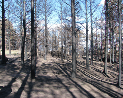
Figure 12. Soils on forested slopes are prone to erosion following events like the 2012 Arapaho Fire. This photo was taken on July 18, 2012, approximately two weeks after the fire burned across RRS and surrounding lands. (Photo by S. Williams)
18
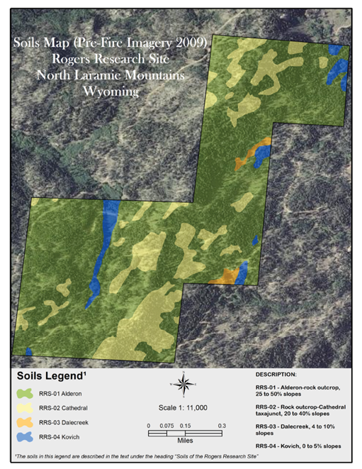
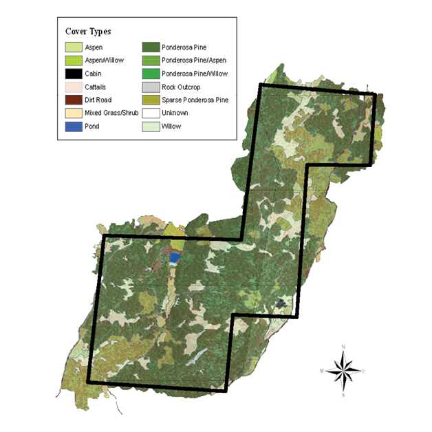
Figure 13. General soils map of the Rogers Research Site, showing the boundaries of the Alderon, Dalecreek, and Kovich soils, and the Cathedral taxajunct. The backdrop aerial image was taken in 2009, three years before the Arapaho Fire. (Soils mapping by L. Munn; digital GIS and cartography work by S. Lanning/WyGISC; aerial base image from the National Agriculture Imagery Program; RRS boundary mapping by Z. Dushdurova, courtesy J. Decker, UW Real Estate Operations)
19
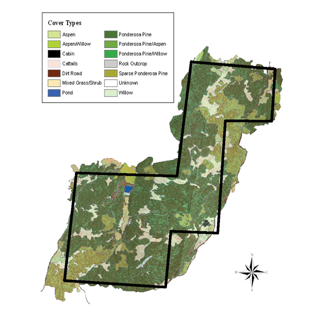
Figure 14. Vegetation map of the Rogers Research Site (from Seymour et al., 2017). The map was created in 2006, when RRS and surrounding lands were mostly forested with ponderosa pine. In 2012, the high-intensity Arapaho Fire burned across the area, consuming most of the vegetation. (Map by Mathew Seymour)
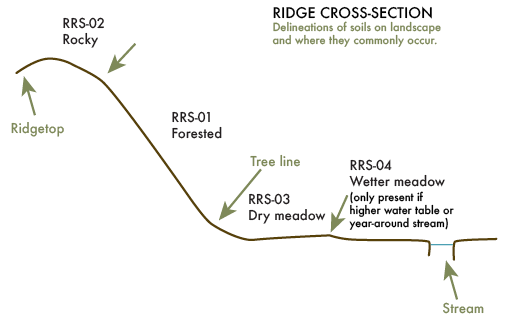
Figure 15. Schematic cross-section of ridge showing representation of common locations of soil mapping units on slope positions at RRS. The four soil mapping units include RRS-01, Alderon (an Alfisol); RRS-02, Cathedral taxajunct (an Entisol); RRS-03, Dalecreek (a Mollisol); and RRS-04, Kovich (a Mollisol). Representative photos showing ‘typical’ ridgelines in the area are on the bottom of this page (Fig. 16A) and on the next page (Fig. 16B). (Soil mapping by L. Munn; illustration by Tanya Engel)
20
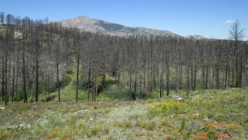
Figure 16A. This photo is a good representation of the schematic cross-section in Figure 15. The dominant Alderon soil (RRS-01/Alfisol) occurs at RRS where ponderosa pine forest historically occupied the steep, convex upper side slopes. The Cathedral taxajunct (RRS-02/Entisol) is shallow to bedrock and occurs intermixed among the bedrock outcrops and the deeper Alderon soils, usually on the upper portions of ridges. The Dalecreek soil (RRS-03/Mollisol) occurs on the concave slopes leading down to stream channels; this soil has a high water table within the profile, which drops during the growing season. The Kovich soil (RRS-04/Mollisol) is dominated by a high water table, organic matter buildup, and accumulation of fine particles (silt and clay) due to its position low in the landscape near springs and along streams. This photo was taken in July 2015, three years after the Arapaho Fire. (Photo by Michael Curran)
A
21
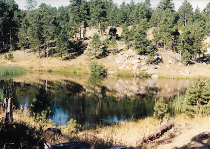
Figure 16B. This photo is a good representation of a major portion of the schematic cross-section of ridgeline shown in Figure 15. The dominant Alderon soil (RRS-01/Alfisol) occurs at RRS where ponderosa pine forest historically occupied the steep, convex upper side slopes, which range from 25 to 50%. The Cathedral taxajunct (RRS-02/Entisol) is shallow to bedrock and occurs intermixed among the bedrock outcrops and the deeper Alderon soils, usually on the upper portions of ridges having slopes of 20 to 40%. The photo (from Williams and Waggener, 2017a) was taken in June 2007, five years before the Arapaho Fire. (Photo by S. Williams)
Figure 17. This photo shows Alderon soil on the slope across from the pond and a small area of Cathedral-rock outcrop. The image (from Seymour et al., 2017) was taken in the 1980s, when ponderosa pine in various age classes dominated the landscape. The small reservoir is fed by spring water and natural runoff. (Photo by Colleen Hogan)
B
and the soil profile shows a light-colored leached mineral layer over a reddish-brown subsoil layer where clay and iron oxides have accumulated. Historically, coniferous forests have been subject to wildfire on a more frequent basis than deciduous forests. After fire, surface protection is greatly reduced, and there is further loss of stability as the roots of the fire-killed trees begin to decay, usually in two to three years (Figs. 3, 12, 19). A combination of coarse-textured soils with low water-holding capacity and moderate clay content lowers water available to support tree biomass. This and the periodic times of low stability after fires results in the soils being only moderately deep to bedrock, approximately 50 to 100 cm (~20–40 in).
Cathedral Series (RRS-02)
The Cathedral soil is shallow to bedrock, less than 50 cm thick (<20 in). It occurs intermixed among the bedrock outcrops and the deeper Alderon soils, usually on the upper portions of ridges having slopes of 20 to 40% (Figs. 13, 15–16, 19–20). The thinness of the soil is related to low weathering ability of the granite and erosiveness of the landscape after fire. These soils may not directly support trees because of their low water-holding capacity, instead supporting scattered herbaceous plants; and they are not as leached as the Alderon Series since they do not have the thick carpet of conifer needles that provide acidity to those soils. Because of lower acid loading and more persistent erosion, these soils do not have the clay accumulation in the subsoil that Alderon soils do and are generally coarser textured and rockier. The landscape positions where the NRCS mapped the Cathedral Series (a Mollisol) on large expanses of more open landscapes, under grassland vegetation, are occupied on the RRS by the
22
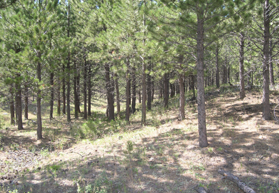
Figure 18. The Alderon soil (RRS-01/Alfisol) occurs where ponderosa pine trees historically occupied slopes at RRS. The trees contributed acid-forming litter to the surface and provided stability to the surface through canopy coverage and root mass. This photo was taken prior to the 2012 Arapaho Fire. (Photo by S. Williams)
23
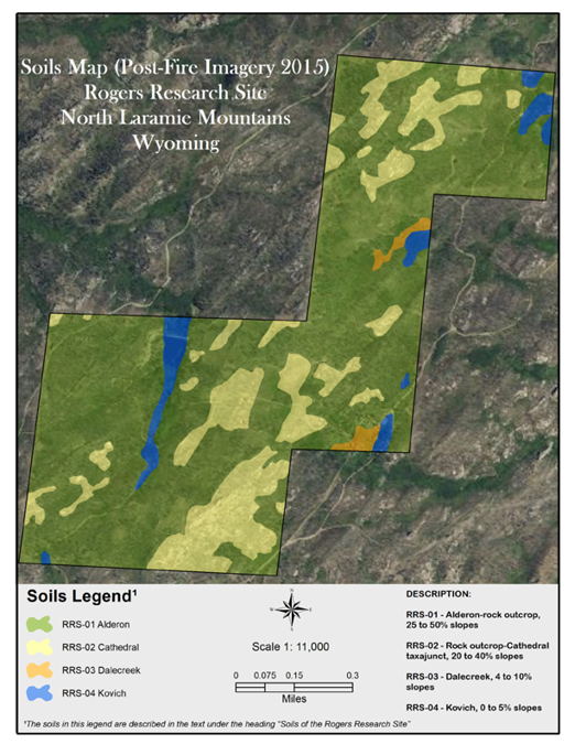
Figure 19. General soils map of the Rogers Research Site, showing the boundaries of the Alderon, Dalecreek, and Kovich soils, and the Cathedral taxajunct. The backdrop aerial image was taken in 2015, three years after the Arapaho Fire. (Soils mapping by L. Munn; digital GIS and cartography work by S. Lanning/WyGISC; aerial base image from the National Agriculture Imagery Program; RRS boundary mapping by Z. Dushdurova, courtesy J. Decker, UW Real Estate Operations)
24
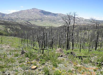
Figure 20. The Cathedral taxajunct (RRS-02/Entisol) is shallow to bedrock, occurring intermixed among the bedrock outcrops (foreground) and the deeper Alderon soil (RRS-01/Alfisol) at RRS, usually on the upper portions of ridges occupied by ponderosa pine (in this case, dead trees from the Arapaho Fire). The Dalecreek soil (RRS-03/Mollisol) occurs below the lower tree line, and the Kovich soil (RRS-04/Mollisol) occurs along the wettest areas in the drainage. This photo was taken in August 2017, five years after the Arapaho Fire. Pictured is undergraduate student Kristina Kline, who is among the many UW students who have assisted faculty and student researchers at RRS. (Photo by Linda van Diepen)
Figure 21. This photo shows Cathedral taxajunct (RRS-02/Entisol) in the foreground and Alderon (RRS-01/Alfisol) on the slope below. The image (from Williams and Waggener, 2017a) was taken in July 2015, three years after the high-intensity Arapaho Fire. In the background is the prominent Laramie Peak (10,272 ft [3,131 m]). (Photo by M. Curran)
25
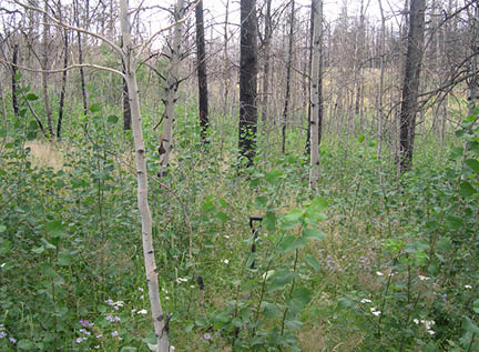
Figure 22. This photo shows Alderon (RRS-01/Alfisol) on the hillside, Dalecreek (RRS-03/Mollisol) as a strip at the base of the hill below the pine trees, and Kovich (RRS-04/Mollisol) in the foreground. The image (from Herget et al., 2018) was taken on June 5, 2015, at a site near RRS. Among the plants in the photo is the moisture-loving Rocky Mountain iris (Iris missouriensis). (Photo by Mollie Herget)
Figure 23. The Dalecreek soil (RRS-03/Mollisol) occurs at RRS below the lower tree line of the coniferous forest on the concave slopes leading down to stream channels. The soil has a high water table within the profile, which drops during the growing season as the herbaceous vegetation transpires groundwater. Quaking aspen often occur in these moist habitats. This photo (from Williams and Waggener, 2017a) was taken in 2013, one year after the Arapaho Fire, and it shows good aspen regeneration. (Photo by S. Williams)
26
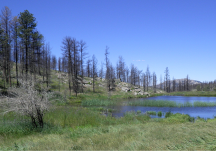
Figure 24. The Kovich soil (RRS-04/Mollisol) is dominated by a high water table, organic matter buildup, and accumulation of fine particles (silt and clay) due to its position low in the landscape near springs and along streams. This soil supports a variety of vegetation, including grasses, forbs, shrubs, and deciduous trees. Also visible in this photo, taken three years after the Arapaho Fire, is a dense patch of Canada thistle (Cirsium arvense), left center. (Photo by M. Herget)
Figure 25. This photo shows Kovich (RRS-04/Mollisol) in the drainage leading to the pond. Also present are Dalecreek (foreground), Alderon (the hillside with living and dead pine trees), and Cathedral-rock outcrop. The image (from Williams and Waggener, 2017a) was taken in July 2015, three years following the Arapaho Fire. In the background is Laramie Peak. (Photo by M. Curran)
27
Cathedral taxajunct (an Entisol) (Fig. 21). The Cathedral taxajunct at RRS is an Entisol because of the lower organic matter content typical of coniferous forest soils.
Dalecreek Series (RRS-03)
The Dalecreek soil occurs below the lower tree line of the coniferous forest on the concave slopes (4 to 10%) leading down to the stream channels (Figs. 13, 15, 19, 22). The soil is very deep (greater than 1.5 m [4.9 ft]), and it has a high water table within the profile. The water table drops during the growing season as the herbaceous vegetation transpires groundwater. Depth to this saturated zone typically varies from 0.8 to 1.2 m (2.5–4 ft) over the summer. The Dalecreek Series has thick surface accumulation of mineral soil enriched in organic matter through both additions by plant roots and through erosion onto the site of surface soil materials from higher landscape positions. Aspen usually occur in these moist habitats (Figs. 4, 23).
Kovich Series (RRS-04)
The Kovich soil is dominated by a high water table, organic matter accumulation, and accumulation of fine particles (silt and clay) due to its position low in the landscape along streams and near springs (Figs. 13, 15, 19, 24–25). Slopes range from 0 to 5%. The water table persists at or near the surface throughout the growing season. This soil is thick, greater than 125 cm (>49 in), and it contains significant accumulation of organic matter, as evidenced by the plant material in Figures 24–25. The soil shows stratification with different layers varying in both color (due to organic matter content) and texture as material is added to the surface by water erosion from the surrounding uplands.
RRS Soils Compared to Adjacent Soils
Areas adjacent to the RRS were mapped by the NRCS (Reckner, 1998) as SMUs 149 and 213. The more detailed mapping of the RRS resulted in replacement of the Cathedral soil (a Mollisol) with the Cathedral taxajunct (an Entisol [Fig. 21]), which has low organic matter content as is characteristic of coniferous forest soils. Physical properties of the Cathedral Series (Reckner, 1998) and the Cathedral taxajunct (Fig. 21; this study) are essentially identical.
Discussion and conclusions
A question that may occur to people viewing the pattern of vegetation at RRS is: Why are the trees confined to the drier, rocky slopes (Figs. 1, 12, 16–18, 20–22, 25–26) while the herbaceous vegetation occurs on the thicker, organic-matter-rich soils along the streams (Figs. 4, 22–26)? Trees, particularly conifers, have to maintain transpiration all year. So, why are they on the thinner, rocky soils with low water-holding capacity? The answer is that fractured bedrock and coarse-textured soils are conducive to woody plant survival because water infiltrates deeply during spring snowmelt and rains, and this water is available to the deep tree roots. The same amount of precipitation water does not penetrate nearly as deeply in the fine-textured, organic-matter-rich soils that support herbaceous vegetation along the springs and streams at RRS. The fibrous roots of the grasses compete with tree roots for the water, and the grasses and forbs can go dormant under late-season drought conditions and survive. After a fire (Figs. 27–28), the herbaceous vegetation will re-grow and provide intense competition to any tree seedlings that sprout from blown-in seed. On the hillsides, which were forested before the Arapaho Fire, the conifer seedlings land on bare mineral soil, and those that become established face no competition for water from the root systems of the herbaceous plant community. The net effect is that the trees typically come back where they were before the fire, and the herbaceous community re-establishes itself almost immediately. (The
28
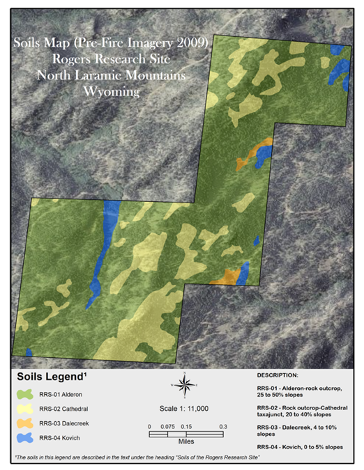
Figure 26. General soils map of the Rogers Research Site in 3-D, showing the boundaries of the Alderon, Dalecreek, and Kovich soils, and the Cathedral taxajunct. The backdrop aerial image was taken in 2009, three years before the Arapaho Fire. (Soils mapping by L. Munn; digital GIS and cartography work by S. Lanning/WyGISC; aerial base image from the National Agriculture Imagery Program; RRS boundary mapping by Z. Dushdurova, courtesy J. Decker, UW Real Estate Operations)
29
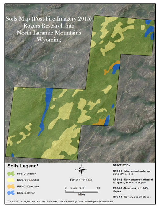
Figure 27. General soils map of the Rogers Research Site in 3-D, showing the boundaries of the Alderon, Dalecreek, and Kovich soils, and the Cathedral taxajunct. The backdrop aerial image was taken in 2015, three years after the Arapaho Fire. (Soils mapping by L. Munn; digital GIS and cartography work by S. Lanning/WyGISC; aerial base image from the National Agriculture Imagery Program; RRS boundary mapping by Z. Dushdurova, courtesy J. Decker, UW Real Estate Operations)
former [ponderosa pine restoration] is part of a long-term study at RRS, which was introduced in RRS Bulletin 5 [Herget et al., 2018].) The boundary between the coniferous forest and herbaceous community is thus surprisingly stable over time. Aspen largely regenerate by root sprouting after the fire, and so they also tend to occupy suitable growing sites over long time spans. The continuous high water table in the Kovich soil would itself be a barrier to upland conifer species.
30
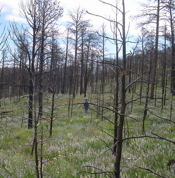
Figure 28. This photo (from Williams and Waggener, 2017a) shows fire response of lupine (Lupinus spp., plant with blue blossoms in foreground) and other forbs and grasses growing in an area at RRS dominated by Alderon soil. It was taken in 2015, three years after the high-intensity Arapaho Fire. (Photo by S. Williams)
31
Acknowledgments
Much appreciation is extended to Shawn Lanning and the Wyoming Geographic Information Science Center (WyGISC) on the University of Wyoming campus for assistance with creating the digital soils maps (Cover and Figs. 11, 13, 19, 26–27). Shawn, a Geographic Information System (GIS) research scientist and data manager with WyGISC, converted the soils data compiled by lead author L. C. Munn into a digital GIS format, and he also completed the cartography of the soils maps. The aerial image (Fig. 6) that Shawn worked from is from the National Agriculture Imagery Program, while the RRS boundary was mapped by Zarifa Dushdurova, a GIS technician with UW Real Estate Operations. The location map (Fig. 5) was provided by the U.S. Forest Service, while overlay details were completed by UW Real Estate Operations Manager Josh Decker and his staff. The base map for Figure 11 is from Esri World Topographic Map.
Thanks to those who reviewed the soils paper in this bulletin: Joseph ‘Joey’ Knelman, a research scientist with the Institute of Arctic and Alpine Research, University of Colorado Boulder, whose specialties include microbial ecology, soil microbiology, and biogeochemistry; two faculty members in the UW Department of Ecosystem Science and Management: Karen Vaughan, an assistant professor of soil pedology, and Linda T.A. van Diepen, an assistant professor of soil microbial ecology; and Stephanie Winters, an M.S. soil science student in the same department.
Long-time north Laramie Mountains’ resident George Portwood provided weather data for this and other RRS bulletins. Appreciation is extended to the incident commander of the Arapaho Fire, Josh McGee, for providing the dramatic photo of the Arapaho Fire. Also providing photos were Colleen Hogan, long-time friend of Colonel William C. Rogers; former UW graduate student Mollie Herget, now an agronomist at the Elsberry Plant Materials Center operated by the NRCS in Elsberry, Missouri (Mollie was the lead author of RRS Bulletin 5: Restoration of ponderosa pine following high-intensity fire); Linda van Diepen, a co-author of Bulletin 5; former UW graduate student Claire Wilkin, now an environmental consultant with WSP in San Jose, California (Claire is a co-author of two upcoming bulletins that detail post-fire soils research at RRS); UW graduate student Michael Curran, who assisted researchers at RRS in a variety of ways, including soil sampling and seedling tree planting; and Jim Freeburn, former director of the James C. Hageman Sustainable Agriculture Research and Extension Center (SAREC) who is now the regional training coordinator for Western Sustainable Agriculture Research and Education. We appreciate the help of Linda Greene, Ron Nichols, Tammy Umholtz, Brenda Ling, and James Bauchert of the NRCS for digging through old files to find the original version of the NRCS soil profile illustration.
Much gratitude is extended to UW Extension’s Office of Communications and Technology for a variety of assistance. Tanya Engel, graphic designer in the office, has spent many hours working on the layout and design of these bulletins, and she has assisted in other aspects of the project as well, including photo editing and printing oversight. Tanya worked with lead author L. Munn and co-author R. Waggener to create the schematic cross-section of the ridge at RRS, showing locations of the various mapping units. Ann Tanaka, website designer/developer, has overseen the posting of each bulletin on the James C. Hageman SAREC website at http://bit.ly/RogersResearchSite. Steve Miller, senior editor in the office, and Chavawn Kelley, writer/editor, have worked with us on news release distribution.
We express gratitude to Mathew Seymour and Ken Driese for granting us permission to publish the vegetation map (Fig. 14) that was at the core of their research for RRS Bulletin 4. Mat, who conducted his RRS project while an undergraduate student at UW, is now a researcher in the Molecular Ecology and Fisheries Genetics Laboratory at Bangor University in Bangor, Gwynedd, United Kingdom. Ken, one of Mat’s mentors at UW, is a senior lecturer in the UW Department of Botany. Leslie Waggener has provided support in a variety of ways throughout development of the RRS bulletin series. Thanks go to Bret Hess, Wyoming Agricultural Experiment Station (WAES) director and associate dean in the UW College of Agriculture and Natural Resources; John Tanaka, SAREC director and WAES associate director; and many others for helping to bring this and other RRS projects (and subsequent bulletins) to fruition.
Finally, we are grateful to the late Colonel William C. Rogers, for it was his gift that is allowing UW graduate and undergraduate students, along with their faculty mentors and others, to carry out research in Wyoming’s great outdoors. May their studies advance our knowledge about wildlife, forestry, and other natural resources for years to come.
32
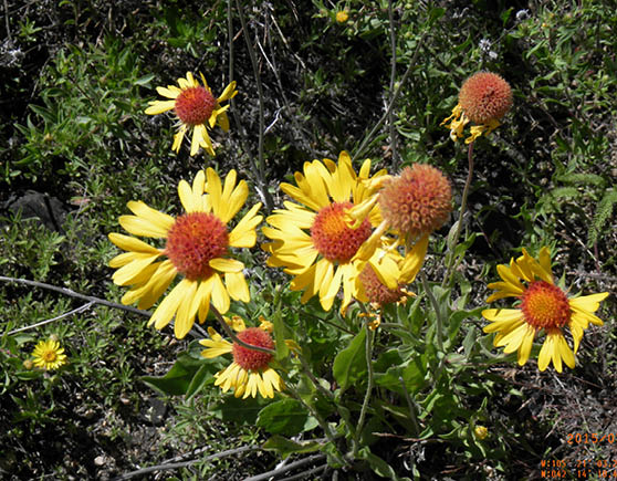
One of the fringe benefits of conducting research in areas like the Rogers Research Site is being able to observe Mother Nature’s beauty, whether towering peaks miles away or wildflowers at one’s feet. Among the numerous forbs at RRS and surrounding lands in the Laramie Mountains is blanketflower (Gaillardia aristata). This photo was taken in July 2015, three years after the Arapaho Fire. (Photo by M. Curran)
33
References cited
Blackstone, D. L., Jr., 1996, Structural geology of the Laramie Mountains, southeastern Wyoming and northeastern Colorado: Wyoming State Geological Survey, Report of Investigations 51, iv + 28 p.
Dokuchaev, V. V., 1883, Russian chernozems (Russkii chernozems), in Monson, S., ed., 1949, Selected works of V. V. Dokuchaev: Jerusalem, Israel, Israel Program for Scientific Translations, v. 1, p. 14–419 (translation from Russian into English by N. Kaner, 1967).
Herget, M. E., Williams, S. E., van Diepen, L. T.A., Winters, S. M., and Waggener, R. W., 2018, Restoration of ponderosa pine following high-intensity fire, Rogers Research Site, north Laramie Mountains, Wyoming: University of Wyoming, Wyoming Agricultural Experiment Station, Rogers Research Site Bulletin 5, iv + 72 p.
InciWeb, 2012, Arapaho Fire: at http://inciweb.nwcg.gov/incident/2959/ (accessed July 2016).
McCahon, T. J., and Munn, L. C., 1991a, Soils developed in late Pleistocene till, Medicine Bow Mountains, Wyoming: Soil Science, v. 152, p. 377–388.
McCahon, T. J., and Munn, L. C., 1991b, Early and middle Pleistocene paleosols in the Medicine Bow Mountains, Wyoming: Soil Science, v. 152, p. 472–484.
National Drought Mitigation Center, U.S. Department of Agriculture, and National Oceanic and Atmospheric Administration, 2017, U.S. Drought Monitor map archive: Lincoln, Nebraska, University of Nebraska–Lincoln, National Drought Mitigation Center: at
http://droughtmonitor.unl.edu/MapsAndData/MapArchive.aspx
(accessed July 2017).
Packer, B. A., 2000, A floristic study of the Laramie Range, Wyoming [Master’s thesis]: Laramie, Wyoming, University of Wyoming, v + 105 p.
Reckner, R., 1998, Soil survey of Albany County area, Wyoming: U.S. Department of Agriculture, Natural Resources Conservation Service in cooperation with Wyoming Agricultural Experiment Station, U. S. Forest Service, and U.S. Bureau of Land Management, xi + 540 p., 41 sheets, at
http://www.nrcs.usda.gov/Internet/FSE_MANUSCRIPTS/wyoming/albanyWY1998/albanyWY1998.pdf (accessed May 2017).
Rogers, W. C., 2002, Amended living trust of Williams C. Rogers, 18 p.
Seymour, M., Driese, K. L., and Waggener, R. W., 2017, Vegetation mapping of Rogers Research Site, north Laramie Mountains, Wyoming, using high spatial resolution photography and heads-up digitizing: University of Wyoming, Wyoming Agricultural Experiment Station, Rogers Research Site Bulletin 4, iv + 50 p.
Snyder, G. L., Siems, D. F., Grossman, J. N., Ludwig, K. R., and Nealey, L. D., 1995, Geologic map, petrochemistry, and geochronology of the Precambrian rocks of the Fletcher Park-Johnson Mountain area, Albany and Platte counties, Wyoming: U.S. Geological Survey Miscellaneous Investigations Series Map I-2233, scale 1:24,000, 2 sheets.
Soil Survey Staff, 1999, Soil taxonomy: A basic system of soil classification for making and interpreting soil surveys (second edition): U.S. Department of Agriculture, Natural Resources Conservation Service, Agricultural Handbook 436, 886 p., at
https://www.nrcs.usda.gov/Internet/FSE_DOCUMENTS/nrcs142p2_051232.pdf (accessed February 2018).
Soil Survey Staff, 2014, Keys to soil taxonomy (12th edition): U.S. Department of Agriculture, Natural Resources Conservation Service, viii + 362 p., at
https://www.nrcs.usda.gov/wps/portal/nrcs/detail/soils/survey/class/taxonomy/?cid=nrcs142p2_053580 (accessed February 2018).
U.S. Department of Agriculture, Natural Resources Conservation Service, 2017, Soils: The 12 orders of soil taxonomy, at
https://www.nrcs.usda.gov/wps/portal/nrcs/ detail/soils/edu/?cid=nrcs142p2_053588 (accessed January 2017).
U.S. Forest Service, 2017, Water, air, and soil, at https://www.fs.fed.us/science-technology/water-air-soil (accessed July 2017).
Waggener, R. W., 2017, Wide constituency guides early activities and research at Rogers Research Site, north Laramie Mountains, Wyoming: University of Wyoming, Wyoming Agricultural Experiment Station, Rogers Research Site Bulletin 2, iv + 26 p.
Williams, S. E., and Waggener, R. W., 2017a, Introduction to the University of Wyoming’s Rogers Research Site, north Laramie Mountains, Wyoming: University of Wyoming, Wyoming Agricultural Experiment Station, Rogers Research Site Bulletin 1, v + 68 p.
Williams, S. E., and Waggener, R. W., 2017b, A conceptual framework to guide research, teaching, and extension at the Rogers Research Site, north Laramie Mountains, Wyoming: University of Wyoming, Wyoming Agricultural Experiment Station, Rogers Research Site Bulletin 3, iv + 60 p.
34
Young, J. F., and Singleton, P. C., 1977, Wyoming general soil map: University of Wyoming, Wyoming Agricultural Experiment Station, Research Journal 117, 1 sheet, 40 p. text.
35
Appendix A. Classification of soils
at the Rogers Research Site.
SOIL CLASSIFICATION TERMS EXPLAINED
Soil classification can seem complicated to those who do not use the system regularly. There is, however, a lot of information conveyed by the taxonomic system. The following is an explanation of soils in the soil mapping units delineated at the Rogers Research Site (RRS), north Laramie Mountains, Wyoming. The references for classification are from Soil Survey Staff, 1999, 2014.
Alderon (RRS-01): fine-loamy, mixed, superactive, frigid Typic Haplustalfs moderately deep
36
Cathedral (RRS-02): loamy-skeletal, mixed, micaceous, frigid Lithic Haplustolls shallow
Cathedral taxajunct: loamy-skeletal, mixed, micaceous, frigid Lithic Ustorthents shallow
“Taxajunct” means that this soil is, in many characteristics, similar to Cathedral, but with at least one major difference. In this case, the soil is an Entisol rather than a Mollisol because it lacks the thick, dark surface mineral layer characteristic of the grassland soils, which is required for a soil to classify as a Mollisol. The mineral features of the soil are otherwise similar to the Cathedral series, and interpretations in the Soil survey of Albany County area, Wyoming (Reckner, 1998) can be used with confidence.
Dalecreek (RRS-03): fine-loamy, mixed, superactive, frigid Aquic Cumulic Haplustolls very deep
Kovich (RRS-04): fine-loamy, mixed, superactive, frigid Cumulic Endoaquolls very deep
Other soils present: Inceptisols
In addition to the soil series used in the four soil mapping units for RRS, there are soils on the hillsides that would classify as the Order Inceptisols. These soils were observed both during vegetation and soil microbial investigations (S. E. Williams) and during the soil inventory (L. C. Munn). They were not mapped in the area surrounding RRS during the Albany County soil survey (Reckner, 1998) and were not delineated in this mapping project because of their small areal extent. They occur as a thin transition zone between the Cathedral taxajunct and the Alderon soils adjacent to rock outcrops. The full taxonomy is: loamy-skeletal, mixed, micaceous, frigid Typic Haplustepts, moderately deep. They lack sufficient clay accumulation to meet the requirements for the Alderon soil and contain too many rock fragments. The Natural Resources Conservation Service did not map any Inceptisols in the Laramie Mountains during the Albany County soil survey (Reckner, 1998); however, they are extensive in the Medicine Bow Mountains (Snowy Range) on glacial deposits of Late Pleistocene age (McCahon and Munn, 1991a) with Alfisols occurring there on older landscapes (McCahon and Munn, 1991b.)
37
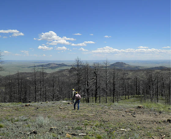
Co-author Steve Williams, left, and University of Wyoming Assistant Professor John Derek Scasta survey the Rogers Research Site on July 23, 2015, approximately three years after the Arapaho Fire burned through the area. (Photo by M. Curran)
A diversity of habitats (from wet to dry), soils (at least four series), and elevations (~2,000–2,200 m) contribute to a wide range of plant species at the Rogers Research Site in southeast Wyoming’s north Laramie Mountains. Among the species is dogbane (Apocynum cannabinum), a perennial herb adapted to mildly acidic to alkaline soil containing loam, clay-gravel, or clay-loam. ‘Dogbane’ refers to the plant’s toxic nature, which can be poisonous to dogs. ‘Apocymum’ is Greek for “away dog.” This photo was taken in July 2015, three years after the high-intensity Arapaho Fire, which burned approximately 98,000 ac (~39,700 ha). (Photo by M. Curran)
Rogers Research Site Bulletin 6
B-1298.6, June 2018